Week 2-Analyze-Determine Sales Territories
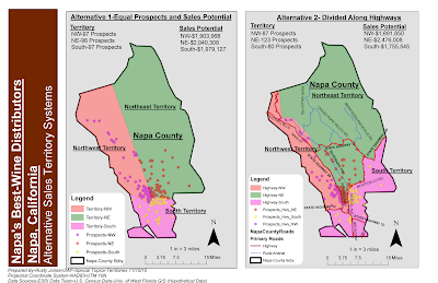
This weeks goals are to provide the fictional company, Napa's Best-Wine Distributors with a sales territory division. One system is to show a somewhat equitable system and the other is to show the territories to being divided by the major roads.
Map 1-Showing two systems for dividing the territories. One system shows an equitable system with a more or less equal number of prospects and sales potential within 5% of the mean of potential sales. The other system divides the territories by the major road system in Napa County.
Map 2- Shows the preferred system of dividing the territory by an equal number of prospects and sales potential, as shown above but with more detail.
I have chosen Alternative 1 as the most equitable system. However, I believe it is possible to design 'highway system' with equality. This would necessitate using local collector streets for the routes. This may result in longer travel times for the sales force. Alternative 1, I believe is more fair. It divides the highest density area (Napa City) amongst the sales people. I also believe that the County is not so large to create a burden, although the salesperson in the South territory will have less driving to make the sales calls. With that said, I believe most salespeople would prefer a system of equality in prospects and sales potential. Given enough time and understanding the true driving times, the highway system may have merit, but it may be difficult to design?


No comments:
Post a Comment